How to Use Drones for Wildlife Conservation?
- August 28, 2024
- 0 comment
Discover how drones for wildlife conservation are transforming efforts to monitor, protect endangered species, and assess habitat health using cutting-edge technology. Drones have revolutionized various fields with cutting-edge technology, and wildlife conservation is no exception. These aerial devices offer innovative monitoring solutions, protecting, and managing wildlife and their habitats.
The Role of Drones for Wildlife Conservation
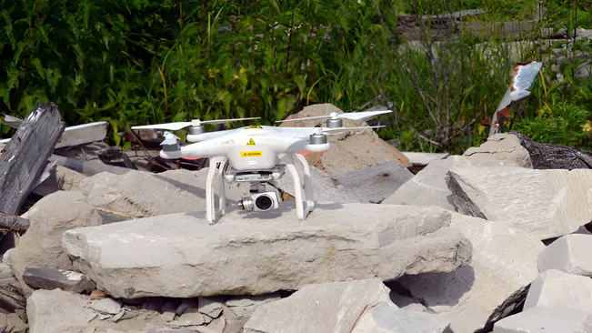
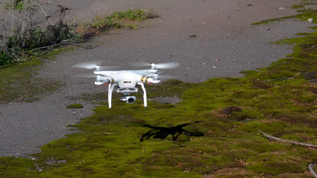
Drones, or unmanned aerial vehicles (UAVs), provide conservationists with unique perspectives and capabilities that traditional methods cannot match. Their applications in wildlife conservation are vast, ranging from monitoring animal populations to detecting illegal activities and assessing habitat health.
Monitoring Wildlife Populations
Drones equipped with high-resolution cameras and thermal imaging sensors allow conservationists to monitor wildlife populations from the air. This aerial perspective is particularly useful for surveying large or remote areas that are difficult to access on foot.
Counting Animal Numbers
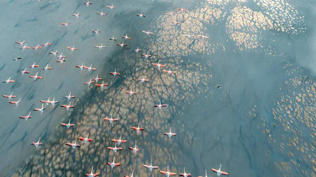
Drones equipped with high-resolution cameras can capture detailed images and videos of wildlife, allowing for accurate population counts. This method is particularly advantageous for species that are difficult to observe from the ground or in areas where traditional surveying methods are challenging.
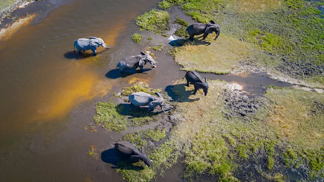
- Precision and Efficiency: Drones can cover large areas quickly and efficiently, making them ideal for surveying species that inhabit vast or remote regions. The high-resolution imagery allows conservationists to count individual animals, even in large herds or flocks, with greater accuracy than ground-based methods.
- Repeatability: Drones enable repeated surveys of the same area, providing consistent data over time. This is crucial for monitoring population trends and understanding the dynamics of wildlife populations.
- Non-Invasive Monitoring: Unlike some traditional methods that require physical proximity or tagging, drones can observe animals from a distance, reducing the risk of disturbing them or altering their natural behavior.
Tracking Animal Movements
Understanding the movement patterns of wildlife is vital for conservation efforts, particularly for migratory species or those with large home ranges. Drones offer a powerful tool for tracking these movements in real-time.
- Following Tagged Animals: Many animals are equipped with GPS collars or other tracking devices. Drones can be used to locate and follow these tagged animals, providing real-time data on their movements. This helps in studying migration patterns, territorial ranges, and seasonal behaviors.
- Behavioral Insights: By observing animals from the air, drones can capture behavioral data that might be missed from the ground. For instance, drones can track how animals interact with their environment, how they use different habitats, or how they respond to threats such as predators or human encroachment.
- Migration and Dispersal Studies: For species that migrate or disperse over large distances, drones can track entire groups of animals, such as herds of elephants or flocks of birds, providing valuable information on their migration routes and the factors influencing their movements.
Protecting Wildlife from Poaching
Illegal poaching remains one of the most pressing threats to endangered species worldwide, driving some to the brink of extinction. Drones have emerged as a vital tool in the fight against poaching, offering innovative solutions to enhance surveillance and detection efforts, particularly in remote and challenging terrains. Here’s a deeper look into how drones contribute to protecting wildlife from poaching:
- Surveillance and Patrolling
One of the primary challenges in combating poaching is the vastness of the areas that need to be monitored. Traditional patrolling methods, which rely on foot patrols or vehicle-based surveillance, are often limited by terrain, visibility, and the sheer scale of the landscapes involved. Drones address these limitations by providing an aerial perspective that significantly enhances monitoring capabilities. - Detection of Poachers
One of the most significant advantages of drones in anti-poaching efforts is their ability to detect poachers who might otherwise remain hidden from traditional surveillance methods. Equipped with advanced sensors, including thermal imaging, drones can identify individuals and activities that would be nearly impossible to spot from the ground.
Assessing Habitat Health
Healthy habitats are the foundation for the survival and well-being of wildlife. Assessing and maintaining these habitats is crucial for biodiversity conservation, as the health of an ecosystem directly impacts the species that inhabit it. Drones offer a unique and effective way to assess habitat health by providing a bird’s-eye view and detailed data that are often difficult to obtain through traditional methods.
- Mapping and Surveying
Drones equipped with high-resolution cameras and advanced sensors can create detailed, up-to-date maps and 3D models of various habitats. - Monitoring Environmental Changes
Environmental changes, whether natural or human-induced, can have significant impacts on wildlife habitats. Drones play a crucial role in monitoring these changes by capturing high-frequency images and data over time, enabling conservationists to track and respond to alterations in the environment.
Enhancing Research and Data Collection
Gathering Data in Hard-to-Reach Areas
One of the most significant advantages of using drones in research is their ability to reach areas that are otherwise inaccessible or too dangerous for humans. These areas can include rugged mountain terrains, dense forests, swamps, and remote islands. Traditionally, collecting data in such locations required extensive logistical planning, significant time, and resources, often with limited success.
- Remote and Dangerous Locations: Drones can fly over and capture data from locations that would take days or even weeks to reach on foot. For instance, they can be deployed in mountainous regions to monitor elusive species like snow leopards or in dense rainforests to study the behavior of primates without disturbing the natural environment.
- Minimizing Human Impact: In sensitive ecosystems, human presence can alter animal behavior or even damage fragile habitats. Drones allow researchers to minimize their footprint by remotely gathering data, ensuring that the presence of observers does not interfere with the natural dynamics of the environment.
- Disaster-Affected Areas: After natural disasters such as floods, wildfires, or landslides, drones can quickly assess the impact on wildlife and their habitats. This rapid response capability is crucial for initiating timely conservation efforts and planning recovery strategies.
Conducting Aerial Surveys
Aerial surveys conducted by drones are revolutionizing how ecological data is collected and analyzed. These surveys provide a bird’s-eye view of landscapes, allowing researchers to observe and document large areas efficiently.
- Vegetation and Land Use Mapping: Drones equipped with high-resolution cameras and multispectral sensors can capture detailed images of vegetation cover and land use patterns. This data is essential for understanding habitat quality, identifying areas of deforestation, monitoring changes in vegetation over time, and planning restoration projects.
- Water Bodies and Wetlands Monitoring: Drones can survey water bodies such as rivers, lakes, and wetlands, providing valuable data on water quality, hydrology, and the extent of aquatic habitats. This information is vital for managing water resources and protecting aquatic species, particularly in regions where water is scarce or where ecosystems are vulnerable to pollution.
- Tracking Environmental Changes: By conducting regular aerial surveys, drones help track environmental changes over time. Researchers can compare images taken at different intervals to identify trends such as habitat loss, climate change impacts, or the spread of invasive species. This long-term monitoring is crucial for making informed conservation decisions and adapting management strategies as needed.
- Wildlife Counting and Behavior Studies: Aerial surveys allow for accurate wildlife counting, especially for species that are difficult to observe from the ground. Drones can also capture videos of animals in their natural habitats, providing insights into their behavior, social interactions, and movements across landscapes.
Best Practices for Using Drones in Wildlife Conservation
To maximize the benefits of drones in wildlife conservation, it’s essential to follow the best practices:
- Compliance with Regulations: Ensure that drone operations comply with local and national regulations, including permits and flight restrictions. This helps avoid legal issues and respects wildlife and habitat protection laws.
- Minimizing Disturbance: Operate drones in a manner that minimizes disturbance to wildlife. Avoid flying too close to animals or during sensitive times, such as breeding seasons, to prevent causing stress or behavioral changes.
- Integrating with Ground Teams: Collaborate with ground teams to coordinate drone operations with on-the-ground conservation efforts. This integration ensures that drone data is effectively used and supports overall conservation goals.
- Maintaining Equipment: Regularly maintain and calibrate drones to ensure they function correctly and provide accurate data. Proper maintenance also extends the lifespan of the equipment.
Conclusion
Drones are transforming wildlife conservation by providing innovative solutions for monitoring, protecting, and managing wildlife and their habitats. Their ability to cover large areas, capture high-resolution data, and enhance research efforts makes them an invaluable tool for conservationists. By adhering to best practices and integrating drone technology with traditional methods, we can enhance our efforts to safeguard wildlife and preserve their natural habitats for future generations.
FAQs
1. What types of drones are used in wildlife conservation?
Drones used in wildlife conservation vary based on their purpose. Common types include multi-rotor drones for close-up, high-resolution imaging; fixed-wing drones for covering large areas; and hybrid drones that combine features of both. Some drones are also equipped with thermal imaging or other specialized sensors for specific tasks.
2. How do drones help in monitoring wildlife populations?
Drones assist in monitoring wildlife populations by capturing high-resolution images and videos from the air. They can provide accurate population counts, track animal movements, and observe behavior without disturbing the animals, offering valuable data for population management and conservation planning.
3. Are drones effective in detecting poachers?
Yes, drones are effective in detecting poachers. Equipped with thermal imaging, drones can spot poachers and illegal activities, even in low-light conditions or dense vegetation. They provide real-time surveillance and help anti-poaching teams respond quickly to threats.
4. How do drones contribute to habitat assessment?
Drones contribute to habitat assessment by creating detailed maps and 3D models of ecosystems. They can monitor changes in land use, vegetation cover, and environmental conditions over time, providing critical information for habitat management and restoration efforts.
5. What are the legal requirements for using drones in wildlife conservation?
Legal requirements for using drones include obtaining necessary permits, adhering to local and national regulations, and respecting no-fly zones. Operators must also ensure compliance with wildlife protection laws and guidelines to minimize disturbance to animals and habitats.
6. How can drones minimize disturbance to wildlife?
To minimize disturbance, drones should be operated at a safe distance from wildlife, avoid flying during sensitive times (e.g., breeding seasons), and use quiet, low-impact drones. Operators should also be trained to understand and mitigate potential impacts on animals.
7. What are the benefits of using thermal imaging drones?
Thermal imaging drones are beneficial for detecting heat signatures, which helps in identifying animals, spotting poachers, and conducting nighttime surveillance. They are particularly useful for monitoring wildlife in dense forests or during low-light conditions.
8. How do drones support research and data collection?
Drones support research by providing access to hard-to-reach areas and collecting high-resolution data on various ecological features. They can perform aerial surveys, gather environmental data, and assist in tracking changes over time, enriching research efforts and conservation strategies.
9. What are the main challenges of using drones in wildlife conservation?
Challenges include regulatory compliance, potential disturbance to wildlife, technical limitations (such as battery life and range), and the need for specialized training. Ensuring data privacy and integrating drone technology with existing conservation efforts can also be challenging.
10. How can conservationists integrate drones with traditional conservation methods?
Conservationists can integrate drones with traditional methods by using drone data to complement ground surveys, enhance monitoring efforts, and inform management decisions. Collaboration between drone operators and ground teams ensures that data is effectively utilized and supports overall conservation goals.
As technology continues to advance, drones stand out as a game-changing tool in the realm of wildlife conservation. Their ability to offer aerial perspectives, monitor vast landscapes, and gather critical data has revolutionized how we approach the protection and management of wildlife. By integrating drones with traditional conservation methods and adhering to best practices, conservationists can enhance their efforts to safeguard wildlife and their habitats. The future of wildlife conservation is taking flight with drones, offering new opportunities to make a meaningful impact and ensure a thriving planet for generations to come.

Kristine Moore
Forestry AuthorI'm Kristine Moore, a seasoned garden landscaping professional with over 30 years of experience. My extensive career has been dedicated to transforming outdoor spaces into stunning, sustainable landscapes. With a deep understanding of horticulture, design principles, and environmental stewardship, I have become a respected figure in the field, known for creating harmonious, visually appealing, and eco-friendly gardens. My commitment to excellence and continuous learning in landscaping trends and techniques has solidified my reputation as an expert in garden design and implementation.


Leave your comment